ACCESS
ACTRIS Services
at more than 40 Facilities
The observational facilities offering transnational access (TNA) are representative for their uniqueness within Europe, offering a comprehensive measurement programme at the forefront of the advancement of research in the specific domains covered within ACTRIS (vertical aerosol distribution, in-situ aerosol properties, trace gases, cloud-aerosol observations) together with state-of-the-art equipment, high level of services, and capacity to provide research-driven training to young scientists and new users.
The 11 facilities listed on this page offer TNA under the ACTRIS IMP H2020 project. More TNA opportunities are offered via the ATMO-ACCESS TNA programme.
- 1. Aerosol remote sensing data centre unit (ACTRIS DC-ARES)
-
Location: Tito Scalo, Potenza, ItalyWebsite: http://www.ciao.imaa.cnr.it/, https://scc.imaa.cnr.it
Description: ACTRIS DC-ARES, operated by CNR, is the main responsible for the Single calculus cHain for Aerosol Remote sEnsing (SHARE), the centralized processing suite for the processing of aerosol lidar data. The Single Calculus Chain (SCC) is currently used by some of the EARLINET/ACTRIS stations and it will become mandatory for the retrieval of ACTRIS aerosol profiling data in the operational phase. ACTRIS DC-ARES provides support in setting up SCC for the stations, configuring it, interpreting the results, but also through web forum, documentation and schools. Based on this unique expertise in the aerosol lidar processing, CNR will offer the SCC use to external users for fostering international cooperation and standardization.
Services currently offered: CNR is currently handling the use of SCC for the aerosol processing for some ACTRIS stations. The harmonized and centralized processing is allowing a faster analysis, traceability and faster developments of advanced products. Opening this to external users will foster international cooperation, but also new advancements in different fields. Currently most of the EARLINET stations use the SCC as ordinary tool to analyze raw lidar data. Lidar stations from Latin American Lidar Network (LALINET) are also starting to use SCC to calculate quality-controlled aerosol optical products, and other aerosol lidar observing stations outside ACTRIS have requested access (the last SSC school has involved 6 external users and 16 associated ACTRIS partners. The access to SCC potentially attracts various user communities and countries: new users from outside Europea for improving the aerosol lidar processing (researcher communities), non academic users (e.g., air quality related stakeholders through use in devoted campaigns). The use of the aerosol lidar processing chain could act as baseline for new products development in the private sector for example at prototype system developments, but even as testing for automatic low power lidar and ceilometer processing delivered by producing SMEs.
- 2. Centre for Aerosol Remote Sensing-Automatic Sun/sky/lunar Photometers (CARS-ASP-FR)
-

Location: Lille, France
Web site: http://www-loa.univ-lille.fr/photons
Description of the facility: The infrastructure is a TC unit for Aerosol Remote Sensing and in charge of instrumental development, characterization, calibration, data preparation and processing for aerosols retrievals of automatic sun/sky/lunar photometers. The facility contributes to the ground-based standardized automatic sun/sky- photometer network AERONET and complements the US NASA calibration centre. The infrastructure consists of photometry and radiometry calibration platforms for calibration of field instruments and the infrastructure holds a mobile platform simulator that allows to test instruments dedicated to mobile observations.
Services currently offered by the facility: The facility offers calibration, quality control, data processing and training services, and expertise in Aerosol Remote Sensing. CNRS-LOA will offer two types of services: (i) calibration and maintenance for sun/sky/lunar/polar photometers; and (ii) services dedicated to mobile photometry for users willing to upgrade their photometer for mobile (e.g., maritime) observation capabilities. Current CE318T photometer has the capability to perform measurements on mobile platform, as already done (e.g on ships). However, additional components are requested. Aerosols products derived from AERONET Europe activities have shown to be very useful and relevant for supporting lidar aerosol retrievals, joint photometer LiDAR retrievals (LIRIC and GARRLIC), aerosol absorption profiling, night-time AOD and satellite and model validation. The scientific applications of delivered aerosol products / services are widely contributing to research activities in many European and worldwide countries (e.g. China) and 50 % of users are from outside the ACTRIS community. Users come from remote sensing, in-situ, and satellite communities and comprise private companies (for testing and calibration of new, e.g. mobile instruments, or users from climate services (e.g UK MetOffice network).
- 3. Central Data Processing Systems for FTIR remote sensing data (CDPS-FTIR)
-

Location: Brussels, Belgium
Website: https://www.aeronomie.be/
Description of the infrastructure: CDPS-FTIR is a processing system running on HPC infrastructure at BIRA-IASB, as part of the TC unit for Reactive Traces Gases Remote Sensing (CREGARS), for processing remote sensing FTIR level 1 data (spectra) to level 2 data (geophysical products, i.e., total column abundances and in some cases vertical concentration profiles of ACTRIS target reactive gases). It consists of a S/W chain, of which the heart is a spectral inversion code agreed in CREGARS, with a web-based interface for communication with the users, including upload of level1 data, and access to the processing results (level2 data and associated processing logbook). CDPS-FTIR is under development: a beta version is expected in 2020, a fully operational system by 2022.
Services currently offered: Preliminary CDPS-FTIR services have already been set up in the frame of Copernicus Atmosphere Monitoring Service (CAMS) projects. This includes central processing of all in-house measurements and of some collaborating stations. Tests with a preliminary CDPS-FTIR version have enabled users to contribute to the CAMS-84 project and resulted in several research papers. The service is available to all external instrument operators in the worldwide FTIR community; most of them are NDACC-affiliated or candidate NDACC affiliates, but also new FTIR operators outside NDACC may appear, e.g., in developing countries (capacity building). There is a strong willingness to have worldwide consistency of the data to enable research that makes use of the global dataset, e.g., for satellite validation. For users of the ACTRIS CDPS-FTIR service, this consistency is automatically ensured and the data will be much more easily integrated in research studies pertaining to the global scale. CDPS-FTIR is also of interest for new instrumental developments, e.g., by a commercial company, which may require verification of the data that CDPS-FTIR can be provide.
- 4. Station for Measuring Ecosystem-Atmosphere Relations II (SMEAR II)
-
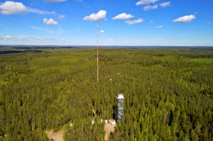
Location: Hyytiälä, Juupajoki, Finland
Website: https://www.helsinki.fi/en/research-stations/hyytiala-forestry-field-station
Description of the facility: SMEAR II represents background boreal forest site consisting of main site at scots pine forest and additional flux measurements in wetland fen and boreal lake environments. The site, represented in the project by UHEL, has several operation units to reach into and above the stand canopy. The site is a world-renowned site for cutting edge aerosol science, multidisciplinary research and having one of the longest time series of atmospheric data (over 20 years). The site contributes to ACTRIS (in-situ aerosol and trace gases, and remote sensing of clouds). SMEAR is comprehensive and co-located ICOS, ACTRIS and LTER site.
Services currently offered by the facility: SMEAR II is operational 24/7, year-round. On-site accommodation and support is in place and open access to comprehensive multidisciplinary SMEAR II data is available. Technical help and instrument monitoring and maintenance for observations during extended periods, research planning and training are provided. SMEAR II has high potential for involving new users due to its reliable infrastructure, multidisciplinary nature of the site and high profile in science. The services aim at specific target users of TNA: instrument developers and SMEs, significant potential for involving users from the private sector; comprehensive instrumentation for benchmarking, on-site electrical engineering staff and technical staff to help in troubleshooting and instrument development, in-depth calibration and verification laboratories available upon request, development and testing of new technologies/scientific exploration, new instruments, and co-development, hands-on training activities at the site. SMEAR II data has provided novel insights into various atmospheric processes. These results are published in over 30 Nature or Science papers. SMEAR II has hosted over 50 multi- and cross-disciplinary campaigns and has over 2300 users annually.
Novel remote access capabilities added: Installation, operation and maintenance of guest instrumentation, virtual training opportunities, instrument benchmarking, field calibrations for selected instrumentation.
- 5. High Altitude Research Station Jungfraujoch (JFJ)
-
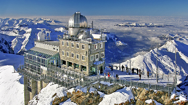
Location: CH-3801 Jungfraujoch, Switzerland
Web site address: http://www.hfsjg.ch/jungfraujoch
Description of the facility: The research programmes on trace gases (i.e. greenhouse gases, reactive air pollutants) and aerosols at the JFJ are among the most comprehensive worldwide. JFJ (3450 m asl), represented in the project by PSI, is the highest research station in Europe that is accessible all year round by rail, and it is the only easily accessible observation point in Europe with adequate infrastructure that is within the free troposphere most of the year. The research station JFJ is therefore of utmost importance for ground-based observations of the free troposphere. As the research observatory is within clouds 40% of the time throughout the year, it provides a unique opportunity for in situ studies of liquid clouds (in summer) and mixed-phase and glaciated clouds (in winter).
Services currently offered by the facility: Users will have access to JFJ measurement platforms to deploy and operate instruments and to data from continuously operating instruments (access to real-time and archived data). The high scientific quality of the atmospheric research is demonstrated by the more than 100 peer-reviewed publications from PSI and EMPA with JFJ data on aerosol and gas phase composition and aerosol-cloud interaction (e.g., Bianchi et al., Science, 352, 1109, 2016; Bukowiecki et al., Aerosol and Air Quality Research, 16, 764, 2016). The JFJ has been massively overbooked by access requests in the past and has high potential to attract new scientific users, as well as users from the private sector. Physical access is offered to a broad variety of atmospheric scientists. Examples of activities comprise closure of organic species in the gas and aerosol phase (links to EUROCHAMP and various CFs), characterization of black carbon, investigation of vertical transport processes, or aerosol-cloud interactions. Testing of newly developed instruments by companies will be supported by cutting-edge complementary instrumentation. The data have high potential to be used by public services such as clear air authorities, and the site has sufficient maturity to provide capacity building e.g. by attracting new facility operators.
Novel remote access capabilities added: Installation, operation and maintenance of specific instrumentation to be operated remotely.
- 6. Cabauw Experimental Site for Atmospheric Research (Cabauw)
-
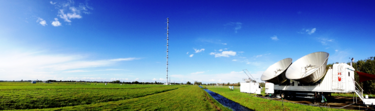
Location: Lopik, The Netherlands
Web site address: http://ruisdael-observatory.nl/?page_id=388, www.cesar-observatory.nl
Description of the facility: At Cabauw (51.971° N, 4.927° E), represented in the project by KNMI/TUD, a uniquely comprehensive set of parameters is measured using state of the art instrumentation to study the physical and chemical atmosphere and its interaction with the land surface. The 213 m high Cabauw tower was built in 1972 for meteorological research to study the state of the atmospheric boundary layer linked to land surface conditions. Cabauw offers access for research and host a cloud remote sensing and trace gas remote sensing CF units. The measurement programme supports aerosol in situ observations, aerosol remote sensing, cloud remote sensing and trace gas remote sensing. In-situ trace gases and greenhouse gases are measured for ICOS. Cabauw is part of BSRN, NDACC, GRUAN and Aeronet networks.
Services currently offered by the facility: Cabauw provides access to users for i) Cloud remote sensing – hands on capacity training, developing and testing new technologies and/or scientific exploration (in particular cloud calibration), this will attract users from private sector, ii) aerosol remote sensing equipment (state of the art (Raman) lidar techniques), and iii) mobile trace gas instruments. The data is provided through ACTRIS and ICOS databases, as well as the CESAR database (http://www.cesar-database.nl), to be developed into the Ruisdael Observatory data portal. The database currently has about 1750 unique users. The multi-themed observations continuously provide an attractive environment for external research. Regular large-scale field campaigns are organised in Cabauw, including satellite validation campaigns. The datasets are invaluable for model evaluation. Recent campaigns include CINDI-2 (trace gas remote sensing), PICAB (in situ trace gases), ACCEPT (clouds), INGOS (methane). Users developing new observational sites in foreign countries are attracted to Cabauw for training and testing their equipment. The Cabauw site attracts users from strong upcoming markets such as the solar and wind-power industries and to use data and develop modelling techniques for optimal use of renewable energy sources.
Novel remote access capabilities added: maintenance of user instrumentation by local personnel. Or alternatively a mixed mode can be foreseen: installation of instruments by users and access to the equipment via remote access.
- 7. Sonnblick Observatory (SBO)
-

Location: Mt. Hoher Sonnblick, Kolmstrasse 100, 5561 Rauris, Austria
Web site address: www.sonnblick.net
Description of the facility: SBO, operated by ZAMG, is located within the Austrian Central Alps at 3.106m a.s.l. It is situated in the “Nationalpark Hohe Tauern” at the main alpine ridge, being exposed, detached and nearly emission-free. SBO was established in 1886 and is surrounded by glaciers and permafrost and provides a various research area from the valley Rauris up to the top of Mt. Hoher Sonnblick. Today, the SBO is a station of interdisciplinary research covering the atmosphere, cryosphere, biosphere, lithosphere and the hydrosphere. It is outstanding with the respect to its long-term climate observations and studies on glacier changes. SBO has been involved in many international projects on atmospheric chemistry and physics and is part of the networks GTS, GAW, GCW, GTBN-P, BSRN; NDACC, LTER, etc. It is used for testing instruments before starting campaigns in the Arctic or Antarctica.
Services currently offered by the facility: SBO has a comprehensive portfolio of regular measurements and access for multi-disciplinary applications is offered. Scientists have for a long time been interested in the extreme location of the observatory (e.g. the Nobel-prize winner V.F. Hess for his measurements of cosmic rays were, instrument testing and material analysis by private sector). SBO provides a platform for temporary installation of scientific instrumentation to users, testing instruments, measuring campaigns, dedicated cloud in situ training and workshops. Several measuring campaigns took place and were serviced at the SBO focusing on cloud water chemistry, wet precipitation, analysis of the black carbon content of both aerosol and cloudwater or analysis of scavenging processes in mixed clouds or supercooled clouds, testing and development of a cloud water sampler for high wind speeds. Users have accessed SBO during the EUROTRAC projects, for Saharan dust reports, airborne Inoculation of Microbial Communities in Glacial Environments (Marie Curie Actions-Innovative Training Networks), data, e.g. for CAMS products. External users include governmental institutions and academia, e.g. DLR, University of Utrecht, University of Heidelberg, ETH Zürich, Masaryk University and many Austrian institutions.
Novel remote access capabilities added: installation, maintenance and some calibrations in consultation with the owner of user instruments at SBO. Possibility to take samples as SBO is staffed 24/7 with at least 2 technicians that can assist where possible.
- 8. Unmanned Systems Research Laboratory (USRL)
-

Location: Nicosia, Cyprus (Workshop) |Orounda, Cyprus (airfield)
Web site address: http://usrl.cyi.ac.cy/
Description of the facility: USRL focuses on cost-effective UAV (Unmanned Aerial Vehicle) atmospheric applications (vertical profiling, 3D mapping, plume tracking) with miniaturized and lightweight atmospheric sensors fulfilling ACTRIS QA/QC and SOPs (e.g. Aerosol Number Size Concentration, Black Carbon Concentration). It comprises laboratories (150m²) with weather chamber for sensor qualification, specialised mechanical/electronic workshops, as well as a private airfield and permanent airspace (with max ceiling of 3km altitude) located nearby the Cyprus Atmospheric Observatory (ACTRIS National Facility candidate, https://cao.cyi.ac.cy/). USRL is operated by a team of 13 staff of experienced engineers (electronic, software, system, communication, mechanic /material), professional pilots (flying commercial airliners), and experienced researchers in atmospheric sciences. USRL includes a large fleet of customized UAVs (fixed and rotary wings) with different payload capacity (up to 10kg) and miniature air sensors.
Services currently offered by the facility: USRL provides 1) research support in performing intensive field campaigns (profiling, 3D mapping) of UAV-sensor systems, 2) technical support through customized integration of lightweight sensors into UAVs (multi-copter, fixed wing), 3) innovation support through the optimization of lightweight instrumentation for their specific use onboard UAVs, 4) quality UAV training of new users (pilots and scientists).
USRL has been successfully used in the past for in-situ validation of LIDAR retrieval algorithms (Mamali et al., 2018; Marinou et al., 2019), Ice Nuclei measurements in the cloud region (Schrod et al., 2017), on-flight validation of lightweight absorption sensors (Pikridas et al., 2019), or for the characterisation (weather chamber) of miniaturized aerosol sensors (Bezantakos et al., 2018). USRL was candidate (as TNA provider) for the 3rd TNA call of ENVRI+, and has been successfully used many large international field campaigns (EU-FP7 BACCHUS in Cyprus; H2020-ACTRIS2 in Greece and Finland; AESA-ASKOS in Cape Verde) and for the provision of services to public/private collaborators (e.g. NOA, Greece; CEA, France). Potential new users: ISARRA Community (International Society for Atmospheric Research using Remotely piloted Aircraft; http://www.isarra.org/); >250 members, EU Research Infrastructure (ICOS, EUFAR) partners from the Eastern Mediterranean and the Middle East region, governmental Units for Environmental monitoring, Security and civil protection. Support/training for SMEs developing UAV-sensor technology in compliance with EU directives (i.e. UAV-based stack emissions), for instrument testing and optimization, and training for UAV flight operation.
Novel remote access capabilities added: integration, testing and flights of new atmospheric sensors in USRL drones, performance of research (field) campaigns and UAV-sensor optimization with remote guidance by the end user.
- 9. Atmospheric Chemistry Department - Chamber combined with the Organic Tracers and Aerosol Constituents - Calibration Center (ACD-C/ OGTAC CC)
-

Location: Leipzig, Germany
Description of the facility: TROPOS’ ACD-C/OGTAC uniquely combines chamber and state-of-the-art online and offline measurement techniques. ACD-C is a twin chamber with a broad online and offline instrumentation, including two SMPS, PTR-TOFMS, PTR-QMS, two CAPS, two sub-ppb level NO2 analysers, an AMS, a CI-APi-TOFMS to comprehensively characterize a wide variety of chamber processes. The online ensemble is complemented by extensive offline instruments available in the OGTAC covering the most important separation techniques: ion, gas and liquid chromatography connected to various detectors (MS, UV, PAD, etc.). OGTAC enables users to detect and quantify the most important biogenic and anthropogenic marker compounds from their chamber experiments to examine their formation pathways and their role in the atmospheric multiphase system.
Services currently offered by the facility: TROPOS has a more then 10-year history in providing access for guest researchers from all over the world (scientific activities, measurement campaigns). High-quality research is ensured through the existing excellence for experimental and theoretical investigation of gas-phase processes, SOA formation processes and the processing of biomass burning exhausts. Good chamber practice, hands-on training in online and offline instrumentation relevant for chamber experiments and comprehensive data analysis are a fixed part of the services offered. Users have successfully detected a highly relevant atmospheric BSOA marker compound and its formation mechanism (Kahnt et al., 2010 ES&T, Wang et al., 2018, Faraday Discussions). Hands-on training courses are usually booked out within few days after each call launch. To date, ACD-C has successfully provided access to international users from Europe and the US. The chamber is attractive for toxicologists, biologists, as well as for health and biodiversity studies. ACD-C strongly cooperates with SMEs like Ionicon for PTR-TOFMS technology and Aerodyne for CI-API-TOFMS. These companies will be encouraged to use the service provided by ACD-C/OGTAC.
- 10. Simulation of Atmospheric Photochemistry in a large Reaction chamber in combination with Centre for Reactive Trace Gases In-Situ Measurements – FZ Jülich (SAPHIR-CiGas-FZJ)
-

Location: Forschungszentrum Jülich, Jülich, Germany
Web site address: http://www.fz-juelich.de/iek/ iek-8/EN/Expertise/ Infrastructure/ SAPHIR/ SAPHIR_node.html
Description of the facility: SAPHIR is operated by FZJ and provides a platform for reproducible studies of the atmospheric degradation of biogenic and anthropogenic trace gases and the build-up of secondary particles and pollutants. Controlled artificial trace gas mixtures, ambient air or emissions from plants can be added to SAPHIR. It is equipped with a comprehensive, unique set of sensitive instruments for radicals (OH, HO2, RO2, NO3), traces gases (NOx, N2O5, O3, HONO, OH reactivity, VOC, OVOC), aerosols, and physical parameters. CiGas-FZJ manages the calibration activities for the in situ measurements of NOx within ACTRIS and GAW.
Services currently offered by the facility: The chamber is used for high quality experiments investigating the transformation of gas-phase species and aerosols with i) permanently installed and calibrated instrumentation; ii) additional instrumentation provided by users while planning of experiments is carried out in collaboration with experts from FZJ. The provided services include SAPHIR chamber studies, hands-on training activities on NOx instrumentation, side by side inter-comparisons to reference methods, overarching instrument inter-comparisons, investigation of possible interferences by tuneable atmospheric matrices, and data quality workshops. Especially in the field of atmospheric NOx measurements new techniques emerge, which implies a growing demand for instrument developers for inter-comparisons in exactly defined environments. In the past dedicated instrument intercomparisons for HOx, NO3, N2O5, VOCs, SOA, HCHO and HONO provided significant improvement of the respective techniques. SOA production from biogenic and anthropogenic precursors have been extensively investigated. Photochemical degradation processes of VOC revealed non-classical regeneration of HOx from RO2. In the years 2003 to 2015 scientists from 42 national and international institutions have used the SAPHIR chamber. Currently 20 GAW stations are equipped with NOx-instrumentation supervised by WCC-NOx.
- 11. Atmospheric simulation chamber- European PhotoREactor (EUPHORE)
-

Location: Paterna (Valencia), Spain
Web site address : http://www.ceam.es/WWWEUPHORE /home.htm
Description of the facility: EUPHORE is an installation with two twin outdoor simulation chambers. Its characteristics allow the study of atmospheric behaviour of biogenic and anthropogenic VOCs, formation of ozone and aerosols under near-real conditions thanks to its large size (200 m3 each) and the use of natural light. For gas-phase measurements there are optical, spectroscopic and gas chromatography techniques: LP-FTIR, LP-UV/VIS-DOAS, PTRMS, GC-MS, CIMS and CEAS. There are also O3, NOx, SO2, CO, HONO-LOPAP and HCHO monitors, and systems to measure radiation. OH and HO2 radicals are followed using a LIF-FAGE. Aerosol formation is also measured by SMPS, TEOM, CIMS and other off-line techniques (LC-MS or GC-MS/MS).
Services currently offered by the facility: Scientific services comprise the study of atmospheric behaviour of biogenic and anthropogenic VOCs and semi-VOCs, formation of O3, aerosols and secondary products (determination of life times in air, and degradation products) and validation of photochemical models. Technical services include intercomparison of instrumentation with possibility of accommodating a large number of external instruments, and the use of the chamber to test, develop or improve new instruments or technological solutions. EUPHORE has participated in more than 20 research projects (7 as coordinator). The facility has been used by more than 60 research groups and more than 300 international researchers ( see list of projects at the EUPHORE webpage. EUPHORE has relevant experience in international campaigns, high versatility and potential of adaptation to new industry and specific user’s demands, huge number of external instrumentation can be hosted for joint experiments among different communities (researchers, health, city air-quality managers, etc.) and industrial/research sectors (automotive, low-cost sensors, photo-catalytic, potential harmful market products, etc.).
Novel remote access capabilities added: conduction of experimental campaigns by EUPHORE staff (under the condition that installation of advanced external instrumentation different from EUPHORE instrumentation is not a requirement for the campaign). Extra time and a careful experimental design is needed.
Recommended Links: