Contacts: | Doina Nicolae (CARS leader) | Philippe Goloub (CARS deputy leader)
Shortcuts: | Guidelines & Tools | News & Events
Mission of the TC
The mission of the Centre for Aerosol Remote Sensing (CARS) is to offer operation support to ACTRIS National Facilities operating aerosol remote sensing instrumentation:
- aerosol high-power aerosol lidars
- automatic low-power lidars and ceilometers
- automatic sun/sky/polarized/lunar photometer.
Additionally, the Centre for Aerosol Remote Sensing offers specialized services for the above instruments and related ACTRIS variables, to ACTRIS users of various types: academia, business, industry and public services.
What the TC offers
CARS offers operation support to ACTRIS National Facilities, as well as specialized services to ACTRIS users:
- Training and consultancy for setting up and running an aerosol remote sensing station
- Measurement and data procedures and tools for QA/QC of the lidar and photometer measurements
- Measurement and data quality monitoring, including calibration of photometers, characterization of lidar optical blocks, direct comparison with reference systems, support for debugging, upgrading and optimizing the instruments
Operation support for ACTRIS National Facilities
CARS provides operation support to ACTRIS National Facilities having the “Aerosol remote sensing” certificate. Part of the operation support is provided on schedule, part on demand. Requests for operation support should be addressed directly to CARS.
The complete list of operation support can be found here: Operation support for ACTRIS National Facilities
Specialized services for ACTRIS users
CARS is providing services to users on demand. Requests should be addressed through SAMU (link to SAMU page).
The complete list of specialized services can be found here: Specialized services for ACTRIS users
- Links with associated communities
-
Facilitates the connection of CARS to the scientific world, and includes the organization of workshops for community building, participation to events and meetings organized by the networks, exchange of expertise with various communities, participation of CARS scientists to expert groups, etc. Primary goal: to maintain a vivid collaboration with strategic partners: EARLINET (European Aerosol Research Lidar NETwork), AERONET (Aerosol Robotic NETwork), E-PROFILE, ESA (European Space Agency), EUMETSAT and Copernicus, etc.
- Training and consultancy
-
Enables increasing the expertise of the (candidate) National Facilities, and preparation of staff for undertaking the necessary work, but also spreading ACTRIS standards and methodologies to stakeholders and users. The following activities are organized: a) individual training and consultancy – on request; b) workshops – twice per year; c) webinars – once per month.
- Measurement and data procedures and tools
- Covers the development, update and implementation of all guidelines, procedures and tools for the quality assurance of the instruments, measurements and data, including elements of the central processing if applicable.
- Measurement and data quality monitoring
- Ensures a close control on the quality of the collected data, including on the data products produced at CARS level. It includes calibration of instruments by direct comparison with reference systems, intercalibration of reference instruments, assessment of the instrument performances by specific tests and expert analysis, performance of laboratory tests for characterizing the instrumental biases and calculation of correction factors, ensuring the measurement and data traceability as possible down to standards, support for debugging, upgrading and optimizing the instruments, performing quality checks in real time on collected datasets.
- NF labelling and evaluation
- Refers to the selection of the candidate aerosol remote sensing and cloud remote sensing NFs, and regular evaluation of their performances. It is handled as part of the coordinated ACTRIS labelling process.
- New scientific and technological developments
- Focuses on new developments in the field of CARS, starting from improvement of the measurement techniques, development and testing of new methods and prototypes, up to the development of new measurement strategies and retrieval algorithms for exploiting instruments synergies.
Variables & measurement techniques
Aerosol profile observations are covered in ACTRIS by automatic low-power lidars and high-power lidars. Due to the differences at the hardware level (e.g. laser power and sounding wavelengths), the data products which can be retrieved from these measurement techniques are essentially different.
- Automatic low-power lidars and ceilometers (ALC) are currently used to provide aerosol layering and attenuated backscatter at one wavelength, information which is used in combination with cloud radars and microwave radiometers to complete the cloud classification at the ACTRIS Cloud Remote Sensing National Facilities. In addition, these parameters could be used to study fog formation that is of great importance for visibility studies. The temporal coverage and low overlap of low power lidar instruments is a valuable add-on used to study the diurnal variation of aerosol layers and to trigger advanced measurements performed using high-power lidar instruments. Even single wavelength low-power lidars are able to detect high resolution dynamics of aerosol layers.
- Aerosol high-power aerosol lidars (AHL) are aerosol lidar which thanks to the higher power can provide besides the same quantities reported for the ALL, more quantitative information about the aerosol optical properties. In particular, AHL used to provide profile aerosol optical properties (aerosol backscatter coefficient, aerosol extinction coefficient and aerosol linear depolarization ratio) at one or more wavelengths, allowing subsequent calculation of several spectral parameters (Angstrom exponents, lidar ratios) of the lofted aerosol layers, and therefore aerosol typing.
Aerosol column observations are covered in ACTRIS by automatic sun/sky/lunar photometers (ASP). The state-of-the-art photometric measurement techniques and associated retrieval techniques provide aerosol properties both directly (e.g. daytime and night time spectral extinction AOD and daytime downward sky angular, spectral and polarized radiance) and indirectly (size distribution, refractive indexes, single scattering albedo, spherical fraction, scattering properties (Dubovik et al., 2000, 2014).
Synergies between aerosol profile and column observations are being greatly developed within ACTRIS-1/2 to provide higher-level aerosol variables such as daytime extinction, backscatter, absorption and mass concentration (total, fine, coarse) and columnar aerosols optical and microphysical properties.
Aerosol profile variables |
|
Aerosol column variables |
|
Aerosol synergy variables |
|
Our Units
ACTRIS Centre for Aerosol Remote Sensing is organized in 8 Units which are grouped in 3 clusters, one cluster for each measurement technique. The Units are hosted by 7 research institutions, located in 5 countries: Romania, Germany, Italy, France and Spain
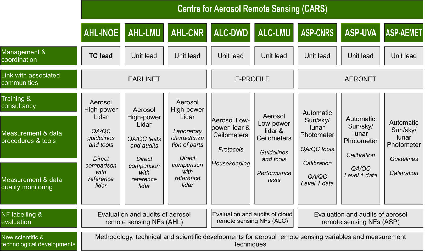
CARS organigram
National Institute of R&D for Optoelectronics (INOE) - INOE is a public research institute under the coordination of the Romanian Ministry for Research, Innovation and Digitalization. The Remote Sensing Department has multidisciplinary expertise and laboratories, spanning from laboratory/in-situ chemical analysis to remote sensing of the atmosphere. INOE is hosting one Unit which is responsible for the QA/QC of the aerosol high-power lidar measurements (CARS-AHL-INOE), and currently ensures the leadership of CARS.
Meteorological Institute of the Ludwig-Maximilians-University (LMU) - LMU is the oldest university in Bavaria, and one of the largest of Germany covering the full spectrum of science with a strong emphasis on natural sciences. The Meteorological Institute is part of the Faculty of Physics. Research focus include radiative transfer modelling and remote sensing (active and passive). It is a key partner of ACTRIS (EARLINET) since the beginning. LMU is hosting two Units: a) a Unit responsible for the QA/QC of the aerosol high-power lidar measurements (CARS-AHL-LMU); b) a Unit responsible for the QA/QC of the automatic low-power lidar and ceilometer measurements (CARS-ALC-LMU).
National Research Council of Italy (CNR) - CNR is the main public research performing organization in Italy, reporting directly to the Ministry of the Education, University and Research. The activities will be specifically performed at the Institute of Methodologies for Environmental Analysis (IMAA). CNR-IMAA has a long expertise in atmospheric research developing methodologies to integrate data from active and passive instruments and to validate models and participates among the others in the following projects: ACTRIS, ACTRIS-2, ACTRIS-PPP, ENVRIplus, EUNADICS, EARLINET, EARLINET-ASOS, GEOMON. CNR-IMAA is hosting one Unit which is responsible for the QA/QC of the aerosol high-power lidar measurements (CARS-AHL-CNR).
Hohenpeissenberg Meteorological Observatory, Deutscher Wetterdienst (HPB-DWD) - HPB-DWD performs research and monitoring of climate and atmospheric composition, which covers meteorology, ozone, precipitation radar, GAW global station, and greenhouse gases within ICOS. The Hohenpeissenberg Meteorological Observatory has contributed in QA/QC by intercomparison experiments and standardization for reactive trace gases VOC and NOx, and remote sensing of aerosol by ceilometers and lidars. HPB-DWD is hosting one Unit which is responsible for the QA/QC of the automatic low-power lidar and ceilometer measurements (CARS-ALC-DWD).
CNRS-Laboratoire d’Optique Atmospherique (LOA-CNRS) - LOA is a joint CNRS and University of Lille research laboratory. Its expertise in aerosols widely covers aerosols remote sensing field both from ground-based observation, as pilot of AERONET network in France and Europe, and satellite observation, as PI of POLDER/PARASOL space missions from CNES and the future 3MI aerosol mission from EUMETSAT. The Laboratoire d’Optique Atmospherique expertise also includes the development and implementation of high-performance aerosol retrieval algorithms such as GRASP. LOA-CNRS is hosting one Unit which is responsible for the QA/QC of the automatic sun/sky/lunar photometer measurements (CARS-ASP-CNRS), and currently ensures the co-leadership of CARS.
University of Valladolid (UVA) - The University of Valladolid was founded in the XIII century and is one of the oldest universities in Europe. The Group of Atmospheric Optics (GOA) belongs to the Optics Department of the Science Faculty, and has a long record in atmospheric research by optical methods for more than 20 years. Since 2006 the GOA group operates an AERONET calibration facility, in close collaboration with AERONET headquarters in NASA, the Laboratory of Atmospheric Optics in Lille and the Izaña Atmospheric Research Center. GOA is hosting one Unit which is responsible for the QA/QC of the automatic sun/sky/lunar photometer measurements (CARS-ASP-UVA).
Izaña Atmospheric Research Center (AEMET-IARC) - The Izaña Atmospheric Research Center (IARC) is part of the State Meteorological Agency of Spain (AEMET). IARC has multidisciplinary expertise and laboratories, therefore contributes to WMO-GAW Programme since 1989, and to other international networks and programs as NDACC, BSRN, AERONET, GAW-PFR. Its main Observatory (Izaña Atmospheric Observatory) dates back to 1916, with uninterrupted meteorological and climatological observations. AEMET-IARC is hosting one Unit which is responsible for the QA/QC of the automatic sun/sky/lunar photometer measurements (CARS-ASP-AEMET).
Our Facilities
Mobile reference instruments
These instruments can be deployed at the user site for direct comparison with user’s field instruments:
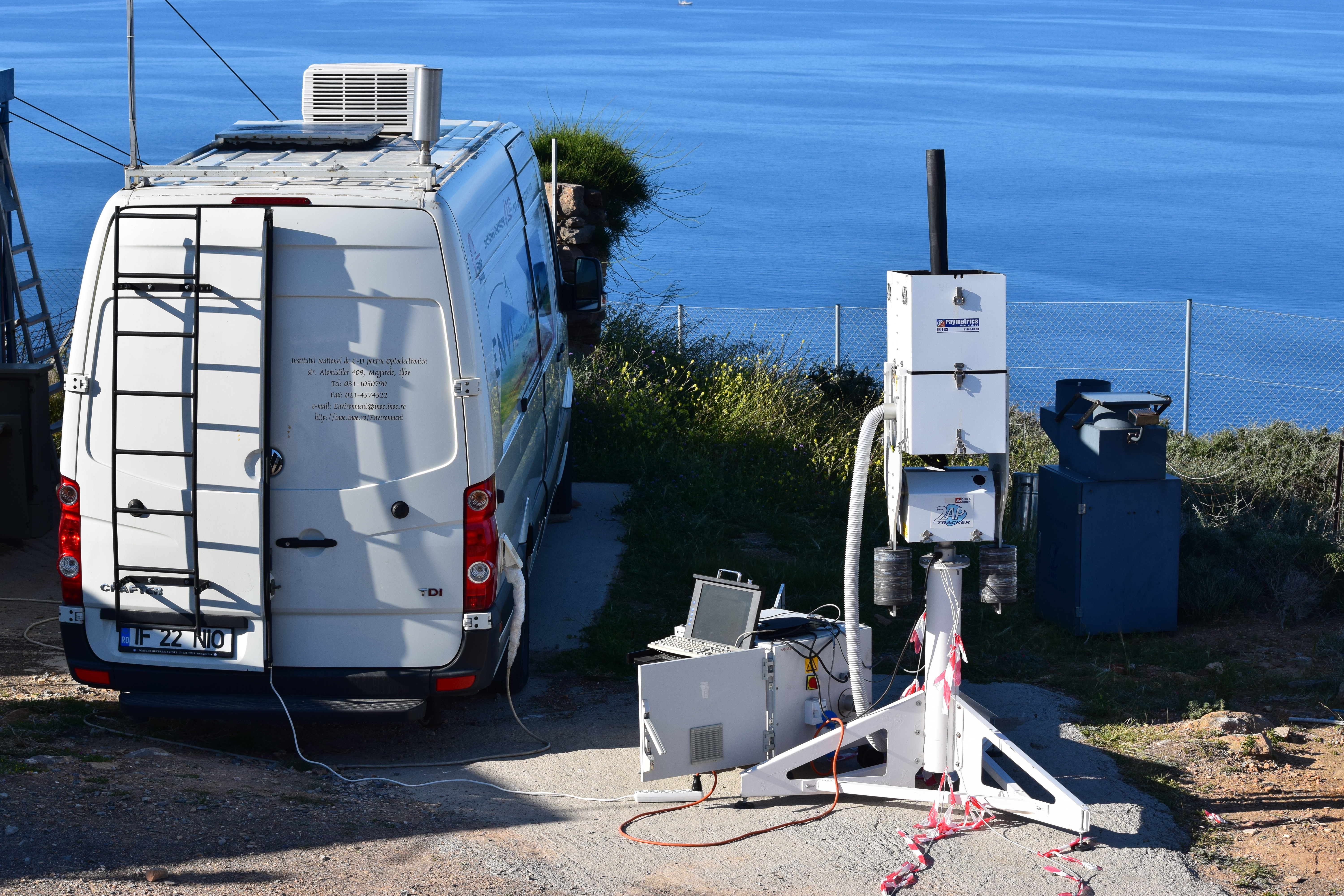
- Reference AHL (mobile): 3 mobile aerosol lidars, various channel setups
- Field automatic sun/sky/lunar photometer: a dedicated set of reference mobile sun/sky/moon photometers to be involved in field campaign or inter-comparison exercises
 |
 |
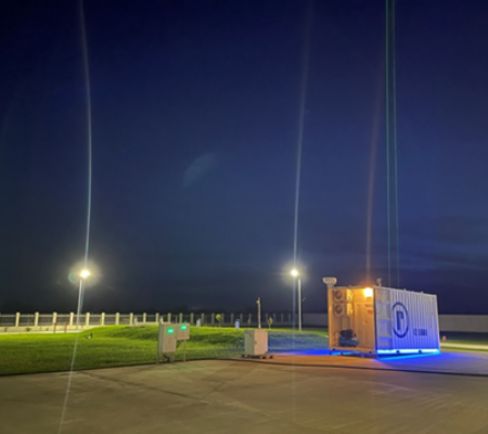
Fixed reference instruments
These instruments are operated at CARS’ locations and are used for direct comparison with user’s field instruments.
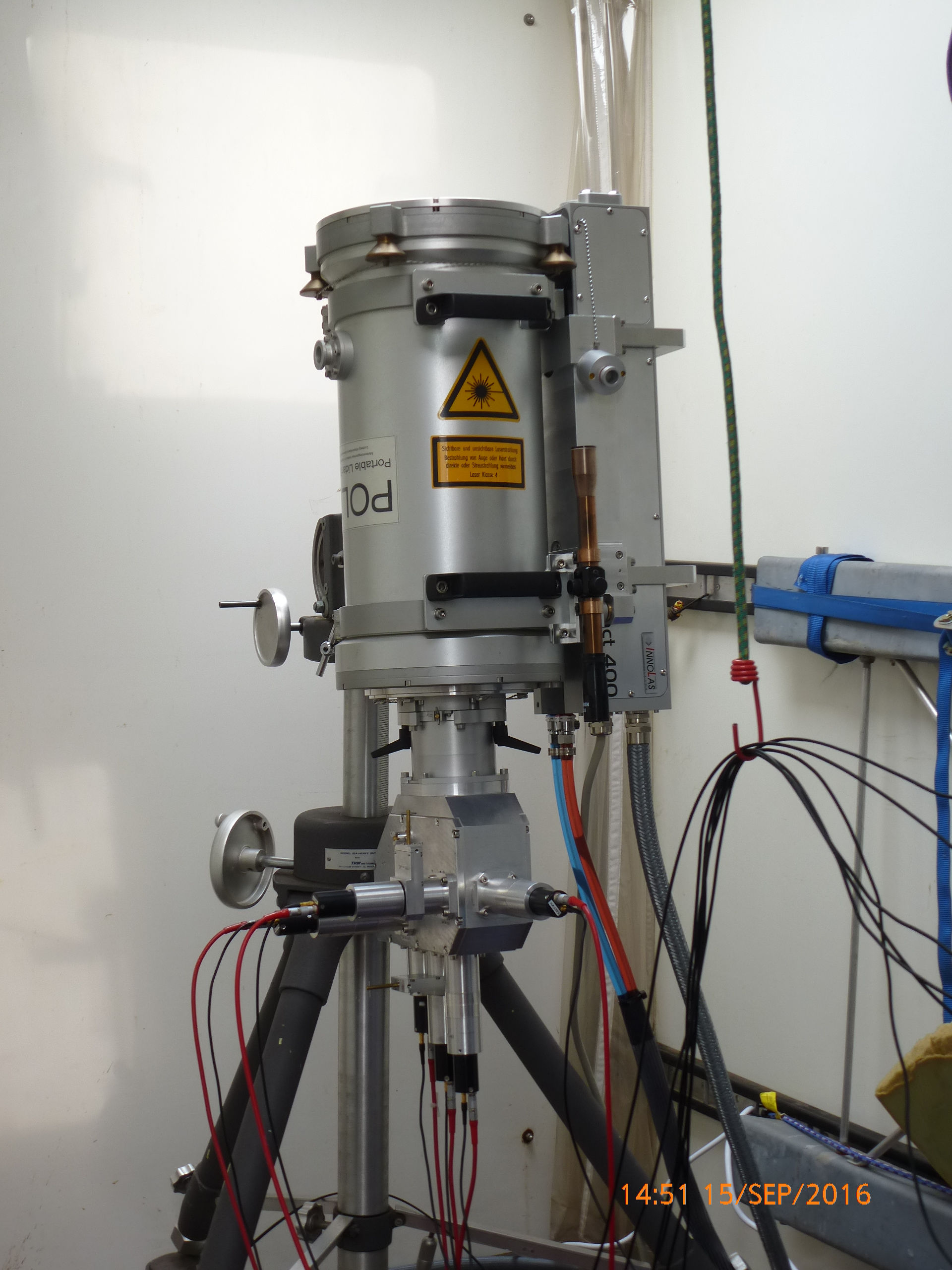
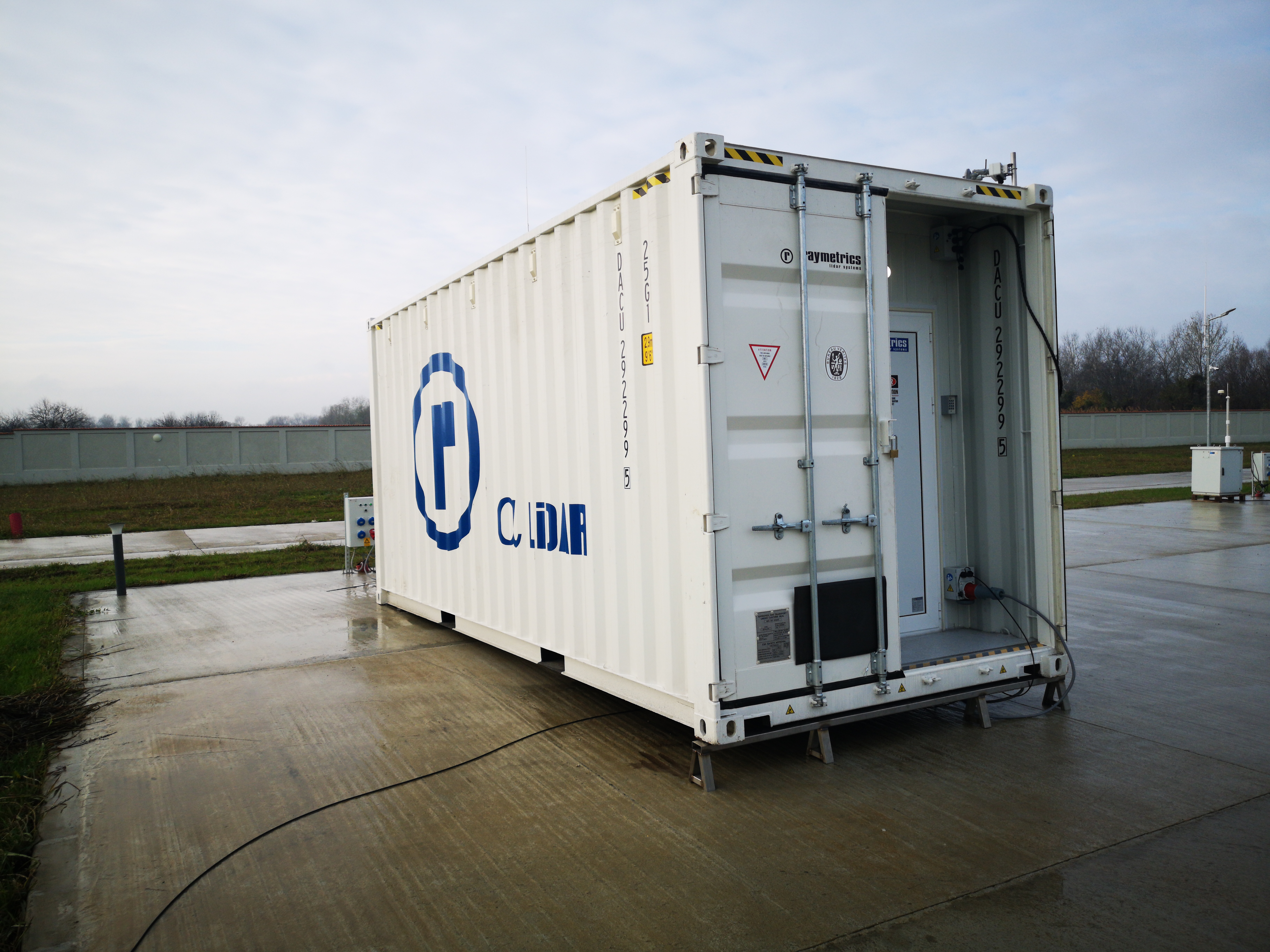
- Reference AHL (fixed): 4 multiwavelength lidar, Raman or HSRL, 3 beta + 2 alpha + 3 delta, dynamic range 200 m to 20 km; complemented by ancillary instrumentation (meteorology)
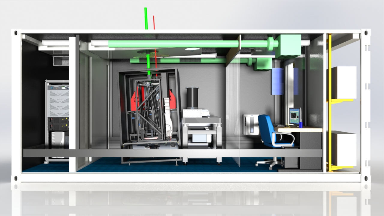
- Modular lidar set-up: 1 modular lidar to set-up different lidar configurations: aerosol fluorescence; tropospheric aerosol optical properties; temperature with rotational Raman from troposphere to stratosphere; liquid water content; HSRL configuration.
- Reference automatic low-power lidars: most commonly used types of low-power lidars
- Master automatic sun/sky/lunar photometer: reference sun/sky/moon photometers to enable calibration transfer, by 3 lines, of about 10 x (robot + data logger) each, to receive field instruments to be calibrated in AOD (absolute error < 0.01) and tested
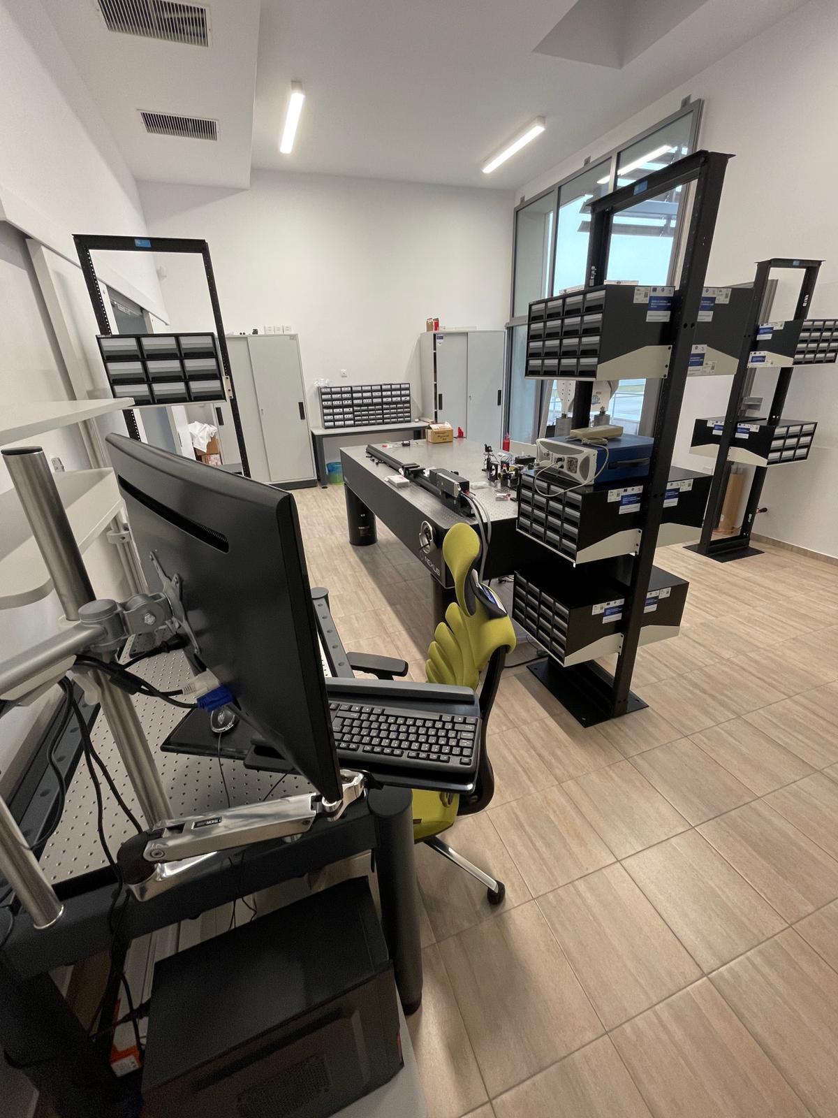
Laboratories
CARS hosts several laboratories for characterization of instruments and components, and calculation of calibration and correction factors.
- Optical laboratory: configurable setups to determine the relevant optical parameters for lidar characterization
- Laboratory and outdoor equipment ASP: calibrated integrating spheres for sky radiance calibration (relative error < 3%), specific linear polarizing system to calibrate polarization (absolute error < 0.005), thermal chambers to measure temperature sensitivity, solar simulator to adjust solar tracking system, mobile reference photometer for internal and external radiance traceability between calibration, spectrometers to control filter transmission, sky-imager and lidar as complementary instruments.